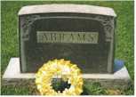
Northampton County - Created in 1634 as one of eight original Shires under the name of Accawmack. It's name was changed to Northampton in 1642/3. Southernmost of Virginia's two counties that form Virginia's Eastern Shore, it is bounded to the north by Accomack County, VA, to the east by the Atlantic Ocean and to the south and west by the Chesapeake Bay. It's greatest length is 32 miles and mean width, if Atlantic islands are included, about 10 miles. It has about 320 square miles. Population: 1820, 7,705; 1830, 8,644;
A
A / B / C
/ D / E / F
/ G / H / I
/ J / K / L
/ M / N / O
/ P / Q / R
/ S / T / U
/ V / W / X
/ Y / Z
| Arlington -
Historical home place of the Custis family, on Rt. 13 south of
Cape Charles. |
|
 |
 Archeological dig |
B
Bayford - small community in nw part of county
on Elliots Neck at Nassawadox Creek
Bayview - small community in the southern part of the county, near the head of Kings Creek, and east of Capeville.
Belle Haven - small community north of Nassawadox.
 Belle Haven Cemetery
- Click here for the growing section showing photos of Belle Haven Cemetery and
the gravestones there.
Belle Haven Cemetery
- Click here for the growing section showing photos of Belle Haven Cemetery and
the gravestones there.
Birdsnest - small community in northern part of county on Rt 13
| Bird's Nest Tavern - Historic landmark tavern in Bird's Nest | |
|
|
|
Brickhouse Neck - a jut of land on the seaside bounded by Mill Creek and Red Bank Creek, and near Hog Island Bay.
Bridgetown - small community in nw side of county at headwaters of Hungars Creek
Brockenberry Bay - small body of water just north of Mockhorn Bay and south of Ramshorn Bay, on the eastern shore of the county at Oyster.
C
A / B / C
/ D / E / F
/ G / H / I
/ J / K / L
/ M / N / O
/ P / Q / R
/ S / T / U
/ V / W / X
/ Y / Z
 Capeville
- situated about 12 miles south of Eastville and north
of Townsend and south of Seaview. In 1836, its population was
25.
Capeville
- situated about 12 miles south of Eastville and north
of Townsend and south of Seaview. In 1836, its population was
25.
Cape Charles - southernmost point of the county

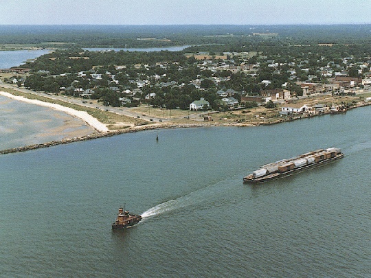 Cape
Charles, Town of - situated on the Bayside, the county's
largest town. The photograph to the left is of Main Street in
1917. The aerial photograph to the right is contemporary.
Cape
Charles, Town of - situated on the Bayside, the county's
largest town. The photograph to the left is of Main Street in
1917. The aerial photograph to the right is contemporary.
Cedar Grove - small community in se part of
county between Kiptopeake and Townsend, east of RT 13.
Cheapside - small community in sw part of county, west of Rt 13 and due west of Capeville.
Cheriton - small community in middle of county on Rt 13 between Oyster and Cherrystone.
Cherrystone Inlet situated on the nw side of the county, Bay side, abutting Savage Neck, Eyreville Neck, Eyrehall Neck, and Cherrystone. Tributaries include: Old Castle Creek, Eyreville Creek, Eyrehall Creek, and Mill Creek.
Chesapeake - small community in the eastern part of the county between Eyrehall Neck and Brockenbery Bay
Church Neck - a large neck of land on the bayside, nw part of the county, bounded by Hungars Creek, west of Bridgetown.
Cobb Island - large barrier island adjoining the Atlantic and east of Cobb Bay and Ramshorn Bay
Crossroads - a small community in ne part of county, just west of Rt 13.
D
A / B / C
/ D / E / F
/ G / H / I
/ J / K / L
/ M / N / O
/ P / Q / R
/ S / T / U
/ V / W / X
/ Y / Z
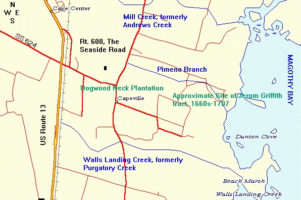
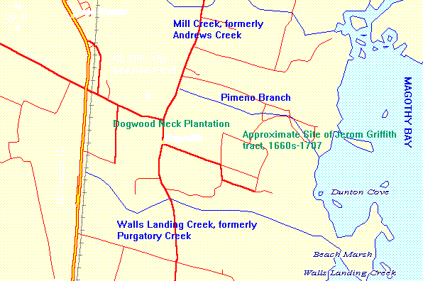 Dogwood
Neck Plantation - Referred to in early 18th Century deeds,
located east of Capeville between Pimino Creek and Purgatory Creek.
Dogwood
Neck Plantation - Referred to in early 18th Century deeds,
located east of Capeville between Pimino Creek and Purgatory Creek.
E
Eastville - situated in the geographic center
of the county and serves at the county seat. its population in
1830 was 217.
Elliotts Creek - small creek in sw part of county, Bayside, and south of Old Plantation Creek
Elliotts Neck - a jut of land on the bayside bounded by Church Creek, Nassawadox Creek, and Warehouse Creek, near Bayford.
| Exmore - a town on the northern edge of the county on Rt 13, just below the county line | |
Exmore Baptist
Church -  |
Exmore
Coca
Cola Plant -  |
Exmore
- The
Trawler Restaurant - Site of the Ghotes 2000 Conference. Also,
site of some of the best seafood on the Eastern Shore. |
|
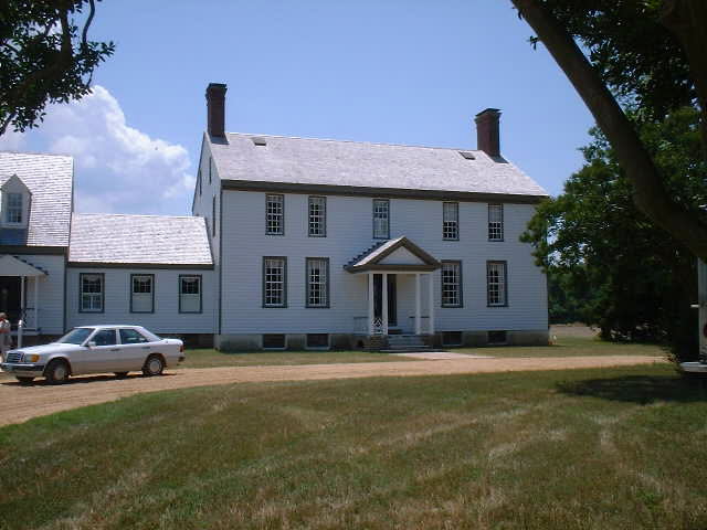
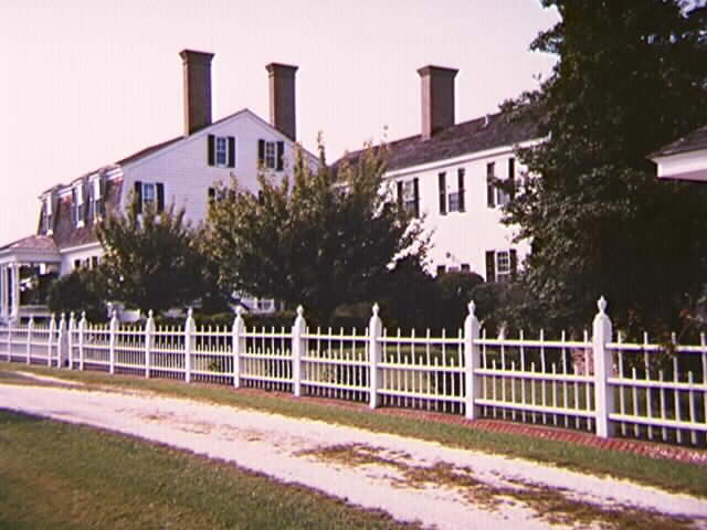 Eyre
Hall - historic home and grounds located in the middle
of the county on the bayside. Click
thumbnail to see larger photograph. According to Whitelaw,
"...Since the early days of the Eyre ownership the home has
been called EYRE HALL. An arrangement sketch of the property on
an insurance policy to John Eyre in 1796 shows at the left the
larger part with double chimneys, and to the right of it a story-and-a-half
wing, as well as a separate brick kitchen. ... The story-and-a-half
structure may bave been erected by Littleton Eyre for his first
home here. Another policy issued just after 1800 shows that part
to have been raised to a full two stories, as in the picture.
The date of the large portion is conjectural, but the last quarter
of the eighteenth century should be a conservative estimate."
(Whitelaw, Vol. 1, pp. 188-191; submitted by Barbara Cox).
Eyre
Hall - historic home and grounds located in the middle
of the county on the bayside. Click
thumbnail to see larger photograph. According to Whitelaw,
"...Since the early days of the Eyre ownership the home has
been called EYRE HALL. An arrangement sketch of the property on
an insurance policy to John Eyre in 1796 shows at the left the
larger part with double chimneys, and to the right of it a story-and-a-half
wing, as well as a separate brick kitchen. ... The story-and-a-half
structure may bave been erected by Littleton Eyre for his first
home here. Another policy issued just after 1800 shows that part
to have been raised to a full two stories, as in the picture.
The date of the large portion is conjectural, but the last quarter
of the eighteenth century should be a conservative estimate."
(Whitelaw, Vol. 1, pp. 188-191; submitted by Barbara Cox).
Eyrehall Creek - a small creek flowing into Cherrystone Inlet, bounded by Eyrehall Neck.
Eyrehall Neck - a small jut of land on the bayside bounded by Eyrehall Creek and Eyreville Creek, west of Chesapeake.
Eyreville Creek - a small creek flowing into Cherrystone Inlet, bounded by Eyreville Neck.
Eyreville Neck - a jut of land on the bayside bounded by Old Castle Creek and Eyreville Creek, west of Simpkins.
F
A / B / C
/ D / E / F
/ G / H / I
/ J / K / L
/ M / N / O
/ P / Q / R
/ S / T / U
/ V / W / X
/ Y / Z
Fairview - small community in southern part of county, east of Cape Charles.
Fisherman's Island - southernmost island of the county, currently serving as home to Fisherman's Island National Widdlife Refuge and is first landfall for northbound traffic on the Chesapeake Bay Bridge Tunnel.
Franktown - small community in nw part of county, w of Rt 13 near Warehouse Creek.
G
A / B / C
/ D / E / F
/ G / H / I
/ J / K / L
/ M / N / O
/ P / Q / R
/ S / T / U
/ V / W / X
/ Y / Z
Great Neck - a small jut of land into the Chesapeake Bay, on the southern end of Church Neck.
Greens Creek - small creek in ne part of county flowing into Machipongo River
The Gulf - creek located on the Bay side, nw side of county separating Old Town Neck and Savage Neck, just west of Eastville.
H
A / B / C
/ D / E / F
/ G / H / I
/ J / K / L
/ M / N / O
/ P / Q / R
/ S / T / U
/ V / W / X
/ Y / Z
Hadlock - a small community in ne part of county on Rt 13 just south of Exmore
Hare Valley - small community in northern part of county on Rt 13 north of Nassawadox
Hog Island - large island located between Atlantic Ocean and Hog Island Bay.
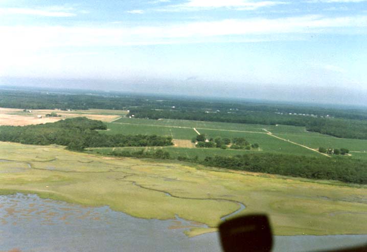
Hog Island Bay - large body of water between Hog Island on the ocean side, Upshur Neck to the north, Ramshorn Bay and Outlet Bay to the south, and the eastern shore of the county, east of Marionville and Nassawadox
Holt Creek - small creek emptying into Ramshorn Bay, near Martins Siding
Holt Neck - a seamarsh island on the seaside adjacent to Ramshorn Bay
Hungar's Creek - large creek on the Bay side, nw part of county, separating Wilsonia Neck and Church Neck. Tributaries include: Jacobus Creek,
 Hungars Parish Church -One of the oldest
churches on the Eastern Shore,
located north of Eastville on the Bayside Road. Current structure dates to Mid 1700s.
Hungars Parish Church -One of the oldest
churches on the Eastern Shore,
located north of Eastville on the Bayside Road. Current structure dates to Mid 1700s.
Photo by Ray Griffin
I
A / B / C
/ D / E / F
/ G / H / I
/ J / K / L
/ M / N / O
/ P / Q / R
/ S / T / U
/ V / W / X
/ Y / Z
Indiantown Neck - body of land on the seaside adjacent to Taylor Creek and Ramshorn Bay and due east of the Town of Eastville.
J
A / B / C
/ D / E / F
/ G / H / I
/ J / K / L
/ M / N / O
/ P / Q / R
/ S / T / U
/ V / W / X
/ Y / Z
Jamesville - small community in nw part of county on Occohannock neck
Johnsontown - small community in nw part of county, w of Rt 13 and west of Hungars Creek
K
A / B / C
/ D / E / F
/ G / H / I
/ J / K / L
/ M / N / O
/ P / Q / R
/ S / T / U
/ V / W / X
/ Y / Z
Kendall Grove - small community in ne part of county, east of Rt 13 and north of Indian Town Neck.
Kings Creek - large creek on the Bayside just north of Town of Cape Charles
Kiptopeake - small community in southern most part of county
L
A / B / C
/ D / E / F
/ G / H / I
/ J / K / L
/ M / N / O
/ P / Q / R
/ S / T / U
/ V / W / X
/ Y / Z
M
A / B / C
/ D / E / F
/ G / H / I
/ J / K / L
/ M / N / O
/ P / Q / R
/ S / T / U
/ V / W / X
/ Y / Z
Machipongo - small community in ne part of county, e of Rt 13
Machipongo River - separates Northampton and Accomack Counties, flowing into Hog Island Bay
Magothy
Bay - Body of water between Smith Island and the sea
marshes and the eastern shoreline of the county, east of Capeville,
Townsend, and Kiptopeake. Often referred to in old land patents
and deeds. Variant spellings include: Magotha,
Marionville - small community in ne part of county, e of Rt 13 and Weirwood.
Martins Siding - small community in ne part of county, e of Rt 13, and near Shadyside.
Mattawoman Creek - located on the Bay side and nw side of county, separating Wilsonia Neck and Old Town Neck.
Mill Creek - creek in ne side of county, emptying into Ramshorn Bay above Webbs Island
Mockhorn Bay - body of water between Mockhorn Island and the sea marshes and the eastern shore of the county, east of Seaview and Oyster, and immediately north of Magothy Bay and Brockenberry Bay.
N
A / B / C
/ D / E / F
/ G / H / I
/ J / K / L
/ M / N / O
/ P / Q / R
/ S / T / U
/ V / W / X
/ Y / Z
Nassawadox Creek - large creek on the Bay side adjoining Occohannock Neck, Wellington Neck, Chruch Neck and Elliotts Neck. Tributaries: Church Creek, Warehouse Creek,
O
A / B / C
/ D / E / F
/ G / H / I
/ J / K / L
/ M / N / O
/ P / Q / R
/ S / T / U
/ V / W / X
/ Y / Z
Oakland Park - small community in ne part of county s of Willis warf on Parting Creek
Old Neck - a small jut of land on the bayside off Occohannock Neck, extreme nw part of county, and bounded by Occohannock Creek.
Old Plantation Creek - large creek on the Bay side, sw part of county, south of Cape Charles
Old Town Neck - a large land mass on the Bayside bounded by Mattawoman Creek and The Gulf, northwest of Eastville.
Occohannock Creek - large creek in nw corner of county separating it from Accomack County, on Bayside.
Occohannock Neck - a large jut of land on the bayside, nw part of county, bounded by the Chesapeake Bay and Nassawadox Creek.
Old Neck - a jut of land off Occohannock neck at Killman Cove on Occohannock Creek
Oyster - small community on the seaside, middle part of county at Mockhorn Bay
P
A / B / C
/ D / E / F
/ G / H / I
/ J / K / L
/ M / N / O
/ P / Q / R
/ S / T / U
/ V / W / X
/ Y / Z

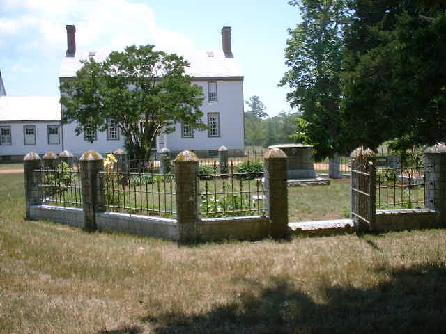
Park Hall Historic Home located in Eastville.
and Cemetery - 
Parting Creek - in ne part of county, east of Exmore and serves are dividing line between Northampton and Accomack Counties
 Pear
Valley - supposedly one of the oldest structures on the Shore,
ca. 1740s; however, its exact location unkown to this writer.
Know where it is? Please email us with details at rgriffin@gamewood.net
Pear
Valley - supposedly one of the oldest structures on the Shore,
ca. 1740s; however, its exact location unkown to this writer.
Know where it is? Please email us with details at rgriffin@gamewood.net
Phillips Creek - small creek in ne part of county flowing into Hog Island Bay
Pimeno
Creek - a small creek, or cut, on the seaside, se part
of county at Capeville, located between Mill Creek (now Andrews
Creek) and Pugatory Creek (now Walls Landing Creek).
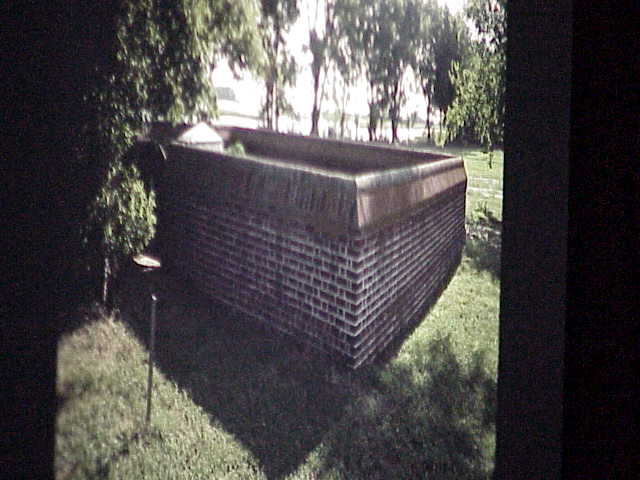
Poorhouse - built for the county's poor after the Revolution. Current structure is pre-civil war. The section build for the county's Black population is post Civil War. The Slaughter house dates to the mid 1700s. The Kitchen is in what is known as the Powell House, thought to be the oldest house on the Eastern Shore, dating from the ca. 1650s. Located on Rt. 13 North of Eastville. Now home to the Barrier Islands Conservancy.
 Poorhouse for whites pre Civil War |
 Poorhouse for blacks ca 1870s |
 Poorhouse Slaughterhouse ca mid 1700s |
 Poorhouse Kitchen aka Powell House ca 1650s |
|
Photos by Ray Griffin |
|
Purgatory
Creek - a small creek on the seaside, se part of county
at Capeville, located just south of Pimeno Creek, now known as
Walls Landing Creek.
A / B / C / D / E / F / G / H / I / J / K / L / M / N / O / P / Q / R / S / T / U / V / W / X / Y / Z
Q
R
A / B / C
/ D / E / F
/ G / H / I
/ J / K / L
/ M / N / O
/ P / Q / R
/ S / T / U
/ V / W / X
/ Y / Z
 Ramshorn
Bay - large body of water just north of Brockenberry
Bay, south of Webbs Island, west of Cobb Island and the sea marshes,
and on the east side of the county, just east of Indiantown Neck,
Holt Neck. The thumbnail photograph is of Ramshorn Chanel. Click
the thumbnail for the full size view. Thanks for Olde Ghote Bill
Wilkins for this beautiful photograph.
Ramshorn
Bay - large body of water just north of Brockenberry
Bay, south of Webbs Island, west of Cobb Island and the sea marshes,
and on the east side of the county, just east of Indiantown Neck,
Holt Neck. The thumbnail photograph is of Ramshorn Chanel. Click
the thumbnail for the full size view. Thanks for Olde Ghote Bill
Wilkins for this beautiful photograph.
Red Bank - small community ne part of county on Red Bank Creek near Hog Island Bay

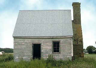
 Red
Bank Baptist Church - the third Baptist Church founded
on the Eastern Shore, located at Marionville in northeastern part
of the county.
Red
Bank Baptist Church - the third Baptist Church founded
on the Eastern Shore, located at Marionville in northeastern part
of the county.
Click here for a brief history of Red
Bank Church.
Click here for a news article account
of Red Bank Church, 13 Oct 1939 (submitted
by olde ghote Dr. Bill Burton)
Click here for the Gravestone Inscriptions,
Red Bank Church.
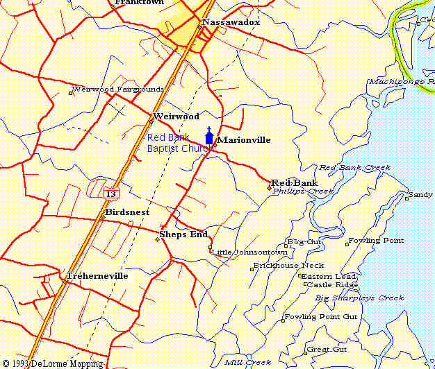
Click the thumbnail map for a detailed area map of the Marionville,
Red Bank, and Nassawadox area.
Click the thumbnail sketch of the Church for a full size view
of the print.

Red Bank Church
Red Bank Creek - small creek in ne part of county flowing into Hog Island Bay
Red Bank Landing - located in Red Bank at the water's edge. Built ca. 1841 when the County Commission wanted to build a public landing. The property upon which the landing was built was owned by Sally Jones Brickhouse Nelson. The County condemned the property, paid her $24 for it and $108 for damages, viz. "Štaking into estimation as well the use of the lands to be laid open for such road as the additional fencing which will thereby be rendered necessary." Submitted by Will Brown. It is further noted that "The landing was made of red brick and small rocks used as ballast. There were no other rocks there and it gave off a red appearance." Submitted by Ruth Williams.
S
A / B / C
/ D / E / F
/ G / H / I
/ J / K / L
/ M / N / O
/ P / Q / R
/ S / T / U
/ V / W / X
/ Y / Z
 Savage Neck - a large jut of land on the bayside bounded by the
Bay, Cherrystone Inlet, and The Gulf. Savage Neck was the home
of the first permanent English settler on the Eastern Shore, Ensign
Thomas Savage. Savage Neck - a large jut of land on the bayside bounded by the
Bay, Cherrystone Inlet, and The Gulf. Savage Neck was the home
of the first permanent English settler on the Eastern Shore, Ensign
Thomas Savage. |
| Highway
marker Photo by Millard J. Driscoll |
Seaview - small community on the seaside, west of Mockhorn Bay and east side of Rt 13.
Shadyside - small community in nw part of county, w of Rt 13 and east of Wilsonia Neck
Simpkins - small community in the ne part of county, east of Rt 13 and near Taylor Creek.
Sparrow Point - located on Occohannock Neck at Occohannock Creek at Chesapeake Bay
T
A / B / C
/ D / E / F
/ G / H / I
/ J / K / L
/ M / N / O
/ P / Q / R
/ S / T / U
/ V / W / X
/ Y / Z
Taylor Creek - small creek on seaside, emptying into Ramshorn Bay at Indian Town Neck
Townsend - small community se part of county between Cedar Grove and Capeville, east of Rt 13
Treherneville - small community in ne part of county, ne of Johnsontown.
U
A / B / C
/ D / E / F
/ G / H / I
/ J / K / L
/ M / N / O
/ P / Q / R
/ S / T / U
/ V / W / X
/ Y / Z
Upshur Creek - small creek in ne part of county, near Nassawadox, flowing into Machipongo River
V
A / B / C
/ D / E / F
/ G / H / I
/ J / K / L
/ M / N / O
/ P / Q / R
/ S / T / U
/ V / W / X
/ Y / Z
W
A / B / C
/ D / E / F
/ G / H / I
/ J / K / L
/ M / N / O
/ P / Q / R
/ S / T / U
/ V / W / X
/ Y / Z
Walls Landing Creek - see Purgatory Creek
Wardtown - small community in nw corner of county on Occohannock neck
Weirwood - small community in ne part of county, e of Rt 13, between Nassadox and Birdsnest.
Wellington Neck - a jut of land on the bayside, in the nw part of the county, bounded by Warehouse Creek and Nassawadox Creek, west of Franktown.
Willis Warf - small community in ne part of county, e of Rt 13 and se of Exmore
Wilsonia Neck - a large mass of land on the bayside bounded by Mattawoman Creek and Hungars Creek.
Woodlawn Historic Home and Thomas Cemetery - located on the Seaside Road south of Exmore. A beautifully restored home dating to the mid 1700s.
|
|
 Thomas Graves at Woodlawn |
photos by Ray Griffin
Y
A / B / C
/ D / E / F
/ G / H / I
/ J / K / L
/ M / N / O
/ P / Q / R
/ S / T / U
/ V / W / X
/ Y / Z
Z
Return to top of Northampton County Index
Return to Gazetteer Index Page
Return to the GHOTES home page
Go to Eastern Shore Map Page
Copyright © 1996- -2000. All rights reserved. Most recent revision
24 November 2000