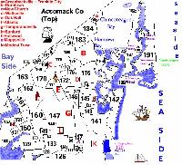
Upper Accomack County
(Sections A126 - A192)

Copyright 1998 by Jim Lokenbauer
These maps of Accomack County and the indices that accompany them were created by ghote Jim Lokenbauer. Jim used data from Whitelaw's Eastern Shore of Virginia, deeds, wills, and other sources to create these new tools. Jim has generously agreed to share them with ghotes and visitors to the ghotes website. As you will see as soon as you start to explore here, Jim has created an extremely valuable research tool for everyone interested in the history of the Eastern Shore and Eastern Shore families. Proximity has repeatedly been recognized as the key predictor of relationships, and here you have an informative and fascinating tool that will let you see how near or far individuals may have actually resided from one another.
Our sincere thanks go to Jim. We greatly appreciate all the hours that went into this labor. We also appreciate Jim's generous nature—from which we all benefit now!
Thanks also to our webmaster Jack Burn for getting these files onto the site in a way that is so useful. There are now "hot spots" on the maps so that you can see "who lived where" just by clicking on a given map section.
Barbara Cox
June 9, 1998
Where Did Your Ancestors
Live?
Use Jim Lokenbauer's Accomack Maps
and Family Locator Files to Find Out
Click on a map below to see its full screen version. The maps are laid off in numbered sections that correspond to the sections used by Whitelaw. The files that follow each map list the names of people who lived in each section between 1600 - 1800. Search the Master Index file for your ancestor and locate the section number(s) for that individual. You can now click on the section number on the maps to see who the neighbors were, or locate the area on the map and then use the Individual Patents and Owners files to see who the neighbors were!
Upper Accomack County
(Sections A126 - A192)
Individual Patents and Owners from Upper Accomack County Map 1600-1800
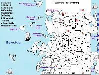
Middle Accomack County
(Sections A59 - A126)
Individual Patents and Owners of Middle Accomack County Map 1600-1800
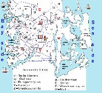
Individual Patents and Owners from Lower Accomack County Map 1600-1800
Return to the top of this page.
Return to the GHOTES home page
Copyright © 1998 Most recent revision Sunday, June 14, 1998 5:18:25 PM